Strategic significance of Andaman and Nicobar Islands
Why in news?
The new thrust on developing strategic infrastructure, both civilian and military, on the Andaman and Nicobar Islands has been long awaited.
Andaman and Nicobar Islands
Location - It consists of two groups of islands at the south eastern edge of the Bay of Bengal.
Strategic arc - The islands form an arc stretching southward between Myanmar and the island of Sumatra, Indonesia. The arc constitutes the boundary between the Bay of Bengal to the west and the Andaman Sea to the east.
Territorial capital - Port Blair (South Andaman Island).
British rule - The Andamans were visited by the navy of the English East India Company in 1789 and in 1872 they were linked administratively to the British to the Nicobar Islands.
Post-Independence - The two set of islands became a union territory of the Republic of India in 1956.
Tribes-
- Andaman- The Great Andamanese, the Onges, the Jarawa and the Sentineles,
- Nicobar- The Nicobarese and the Shompen
What is the strategic importance of Andaman and Nicobar Islands?
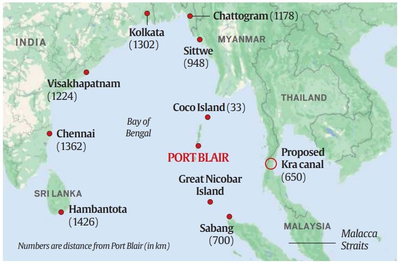
Geopolitical location- Situated at the mouth of the Malacca Strait, the Andaman and Nicobar Islands offer a strategic vantage point for monitoring and controlling maritime traffic passing through one of the world's busiest waterways.
| Strategic location | Significance |
|---|---|
| Sabang in Indonesia | It is 90 nautical miles southeast of Indira Point (on Great Nicobar island) |
| Coco Island in Myanmar | It is barely 18 nautical miles from the northernmost tip of the Andamans. |
| Kra canal to be built by Thailand | The canal would connect the Gulf of Thailand with the Andaman Sea, its mouth would be about 350 nautical miles east of Port Blair. |
| Malacca strait | It connects the Indian Ocean to the Pacific, is less than a day's steaming from Port Blair. |
Strategic chokepoints - The islands are positioned near several strategic chokepoints, including the Malacca, Sunda, Lombok, and Ombai-Wetar straits. Control over these chokepoints is essential for maritime security and trade flows in the region.
Significance of Maritime boundary - The islands share maritime boundary with neighbouring countries like Myanmar, Thailand, Indonesia, and Bangladesh, giving India significant influence over maritime activities in these regions under UNCLOS.
Military importance - The development of military infrastructure on the islands enhances India's ability to project power and deter potential threats from the eastern direction, particularly from China.
Economic potential - The islands offer economic opportunities, including maritime trade, tourism, and fisheries. Developing infrastructure to support these sectors can contribute to islands' economic growth and reduce their dependence on mainland India for essential supplies.
Why the pace of developing strategic infrastructure in the islands has have been slow?
Slow realisation - The unprecedented expansion of China's navy has prompted the island's strategic criticality for India's security.
Infrastructure deficit - The distance from the mainland and the inherent difficulties in developing infrastructure have been cited as reasons for delays in various projects.
Complex procedures - Obtaining environmental clearances, even for small projects, has been a complex process.
Land acquisition - Regulations related to forest conservation and the protection of native tribes have further complicated land acquisition issues.
Multi-dimensional project - Developing the islands and their strategic infrastructure involves coordination across multiple ministries, departments, and agencies. This multi-dimensional effort presents significant challenges.
Political impact - Seeking immediate political gains takes precedence over long term strategic vision.
What should strategic infrastructure development in these islands focus on?
Surveillance - Establishing robust surveillance systems to monitor the vast maritime area stretching 420 nautical miles from north to south is essential to deter potential threats.
Maritime infrastructure - Construction of ports and fuel storages in both the northern and southern groups of the islands is crucial for the operational turnaround of ships without returning to Port Blair.
Military infrastructure - Building military bases, airfields, and naval facilities to enhance defence capabilities and ensure a rapid response to security challenges.
Enhance connectivity - Improving transportation infrastructure, including airports, ports, roads, and ferry services, to facilitate the movement of people and goods within the islands and with the mainland.
Economic development - Promoting economic activities such as tourism, fisheries, and maritime trade through the development of ports, logistics facilities, and tourist amenities.
Sustainable development - Balancing development with environmental conservation by obtaining necessary clearances and implementing eco-friendly practices.
Great Nicobar Project - Accelerating the development of the Galathea Bay transhipment port on Great Nicobar Island is vital. Maritime services such as repair and logistics for both international and Indian shipping need to be established.
Incentivise habitation - Consideration should be given to the planned habitation of uninhabited islands by providing incentives like free or subsidized land to encourage eco-friendly entrepreneurial activities.
International cooperation - Leveraging international partnerships, such as the QUAD and the Indo-Pacific Oceans Initiative (IPOI), to support development efforts and enhance regional stability.
Exam
Recent Affairs
-
5 Bad Landing Page Examples & How We Would Fix Them
Oct 9, 2023Weekend Batch -
How Agile is Your Forecasting Process?
Oct 9, 2023Weekend Batch -
Inclusive Marketing: Why and How Does it Work?
Oct 9, 2023Weekend Batch